💧 Ottawa River Water Level – Britannia
Chart Datum: 57.9 m MASL
📍 Your GPS Location
Checking location…
Rules of the Road

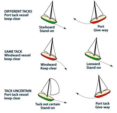
- Rule 1: Same tack → leeward has right-of-way.
- Rule 2: Opposite tacks → starboard tack has right-of-way.
- Rule 3: Overtaking: boat ahead (overtaken) has right-of-way.
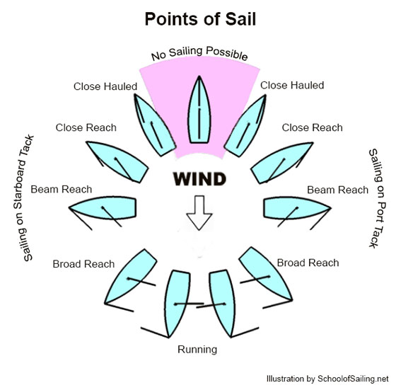
- Note: Starboard tack: wind coming from starboard side.
✅ Before Anchoring
- Check wind & current direction
- Choose a spot with room to swing
- Confirm depth and bottom type
- Calculate scope: 5:1 (calm), 7:1+ (windy)
- Prepare anchor, rode, chain
- Assign hand signals or radio contact
⚓ While Anchoring
- Approach slowly, head into wind/current
- Stop boat — let it drift back
- Lower anchor (don’t throw)
- Pay out rode while reversing gently
- Set anchor: reverse until tension
- Check for drag visually or via GPS
🔒 After Anchoring
- Snub the line with cleat or snubber
- Set anchor alarm if using GPS
- Check reference points
- Log GPS position
- Stow remaining rode
✅ Before Casting Off
- Engine running in neutral
- Check surroundings
- Rudder centered
- Disconnect shore power
- Fenders secured
🪢 Line Handling (Suggested Order)
- Bow line — release first
- Spring line — release second
- Stern line — release last
🕹️ Backing Out
- Engage reverse idle
- Release bow and spring lines as you begin moving
- Release stern line and steer away
- Use short reverse bursts for control
- Shift to forward gear once clear
🔁 Tips
- Use stern spring line to pivot if needed
- Account for wind pushing bow or stern
- Use prop walk or rudder thrust creatively
Sail Reference Info
- VHF Channel 16 – Emergency / Hailing
- Anchoring: 5:1–7:1+ scope
- Prevailing winds: WNW → NW
- Marina: Nepean Sailing Club